Lives saved
1

Hiking

Mountain
Medical emergency
Thunder storm
Federation Park, Tasmania
-42.8290962°S, 147.2786849°E
Posted on May 1, 2018 by Ed
What happened?
On the morning of the 22nd of November 2016, we set out for the summit of Federation Peak in the south west of Tasmania, the objective of our 6 day trek. The area is renowned for its isolation and unpredictably bad weather. The approach to the summit is particularly dangerous requiring climbing some 200 meters of near vertical terrain, not to be tackled in windy or wet conditions. To maximize our chances of summiting, I had allowed an extra day in the initial stages of planning for bad conditions, this all going well would have allowed us 3 days where we would have the opportunity to reach our goal. The walk into and along the mountain range was challenging and we lost a valuable few hours due to the track being completely reclaimed by horizontal scrub. Apart from this the weather was perfect and views were stunning. Due to the delay early in the trip we did not have sufficient daylight to attempt a summit grab on the 3rd day as planned and we set up camp about 1.5 km walking from the peak itself. The following morning we woke to a cold, windy and wet day. When the rain eventually cleared later in the afternoon there was not enough time to summit safely. The following day was to be our last chance.
Waking at 5.30am to thick cloud and windy conditions, we thought the likelihood of a successful summit attempt were next to zero. We packed up camp and headed out. The track we were taking out lead right past the turnoff to the summit. We decided to stop at the junction for a minute for a quick handful of trail mix joking “you never know, it might clear in the next 10 seconds.” Believe it or not but as we sat there the cloud lifted and in the space of 10 minutes we were standing in sunshine, lake Geeves shimmering some 400 meters below. With a “there goes our excuse” we packed day packs with climbing gear and safety equipment and started climbing. The exposure on this climb was like nothing else I have ever experienced, literally 100 metre falls, loose rocks and steep terrain seemingly the entire way up. There is a section just before the summit where you have to climb out onto a tiny ledge with a 300 meter fall directly below you and climb up an arête. We reached the topat 1:30, with the normal celebratory photos and signing the log book before starting our descent. The first few more challenging sections of the downclimb we used ropes as backups to protect against falls, but I decided to tackle an easier section unroped. I approached the vertical crack and lowed myself into it. Hanging on with my fingers a looked for a solid foothold, but could only find loos rocks, then the rock I was clinging to with my left hand broke away. After what seemed like a frantic few seconds while I tried to regain a secure hold my right fingers slipped and I fell.
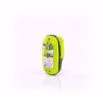
Falling about 2 meters I bounced off a small ledge breaking my right leg. After falling another 6 to 8 metres I landed on my back in a narrow couloir full of loose shale. I slid for a metre or so before self arresting, just short of an even larger fall. I was pretty shaken, my right foot was sticking out at 90 degrees from what it was meant to be but I was alive! Ironically I was the one carrying all the safety gear. After yelling out to the rest of the group that I was OK, I activated the ACR ResQLink we were carrying and set about putting on some warm clothes. It turns out that I had taken a wrong turn and climbed into the wrong crack. The rest of the team set up ropes and downclimbed onto a buttress bout 6 metres from where I was perched. My fiancée traversed across and we sat waiting for rescue.
Luckily the helicopter arrived within an hour as the cloud had started descending. About 30 minutes later my fiancée and I had been winched off the mountain and were en route to hospital. Over the next two days the next two days the remaining members of the group walked out with most of our gear. A good ending to a situation that could have been much much worse.
Special thanks to the Westpac chopper team, the remainder of the climbing party I was with and of course the staff at ACR for supplying such a fantastic product.
Words of wisdom
Special thanks to the Westpac chopper team, the remainder of the climbing party I was with and of course the staff at ACR for supplying such a fantastic product.
Thank you note
Thank you ACR!
Rescue location
Federation Park, Tasmania
Rescue team
Local Search and Rescue